 VectorExpert
Irrigation canals
Bed cut and both banks as separate layers, each with its own quantity.
Canal projects →CivilSurvey Expert · profile surveying & earthwork for Windows
Book levels in a spreadsheet, generate cross- and long sections with up to five layers, adjust them by hand or to a target area, then back-calculate a level book that matches. One project file, built-in CAD, no AutoCAD needed.
Built-in CAD. No AutoCAD licence. No obligations.
 CivilSurvey Expert — CSE_Sample1.CSF · CH 0+03001 / 06 Book the levels B.S., I.S., F.S. → R.L.s by height of instrument, arithmetic checked
| Layers | Project | CAD | Outputs | Licence |
|---|---|---|---|---|
| Up to 5 per section: ground plus 4 design or survey layers | One portable .CSF file holds everything | Built in. No AutoCAD licence, no obligations | Sections, L-sections, area statements, volume abstract, Excel | One-time payment, unlimited sections |
The workflow
Follow chainage 0+030 of the sample canal through the six stages of a job. Each stage runs the same calculation as CivilSurvey Expert. Changes you make while adjusting carry through to the field book generated at the end.
In CivilSurvey Expert
Built-in CAD
Every section is drawn, edited, printed and exported inside CivilSurvey Expert. You don't buy, renew or audit a separate CAD seat to do survey work, and nobody on the team has to learn a second program.
| Job | CivilSurvey Expert | A CAD-dependent workflow |
|---|---|---|
| Draw and edit sections | Built in: drag points, locks, snap, get reading | Needs a CAD licence on every PC |
| Print section sheets | Built in: A0–A5, Letter, batch | Plot from the CAD program |
| Templates from old drawings | Import a DWG into the template designer | Redraw in CAD |
| Hand drawings to others | Export DWG; opens in AutoCAD or any DWG program | Native |
| Licences to keep | One, paid once | Two, often on subscription |
Capabilities
| Capability | What it does for you | Detail |
|---|---|---|
| Input | ||
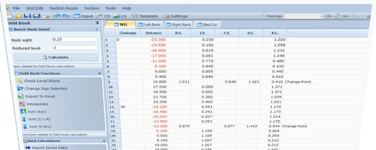
| Field book as a spreadsheet | Every field book and design is a sheet in one project workbook, with formulas, formatting, your own columns and your own sheets. | Ch · Offset · B.S. · I.S. · F.S. · H.I. · R.L. · Remark; chainage only on the first row of each group |
| Excel in and out | Bring in field books from other programs. Columns are recognised by their headings, and a safety copy of the project is kept first. Export the whole project as one workbook. | Ch / station · offset · BS · IS · FS · HI · RL / level · remark; per sheet: new route, replace, add, skip |
| Interpolate chainages | Builds a TIN from the surveyed sections and slices it at a regular interval for a quick intermediate level book. | From · To · Interval → Excel, interpolated rows highlighted |
| Sort, change sign, find | Order each chainage the way your book is written, flip offset signs, and find or replace across all sheets. | Asc · C-L-R · C-R-L; find all; replace is one undo step |
| Layers and templates | ||
| Multiple series | Ground plus up to four layers per section, such as banks, bed cut, earth top or bitumen, each from a field book or a design. | NSL + SERIES 2–5; alias, layer, colour and line type per layer |
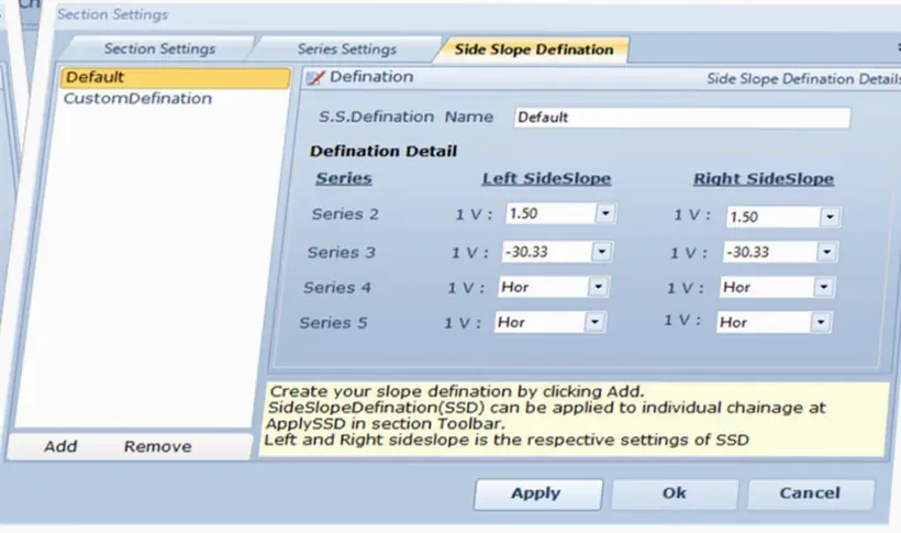
| Side slopes and toe points | Each layer slopes out to the layer you choose, up or down, and the toe is found where they meet. Keep named slope sets and switch them per chainage. | Left and right slope per layer, "1 V : x H"; 0 = vertical |
| Template designer | Draw a typical section once, or import it from an AutoCAD drawing, then place it along a chainage range. | Line, mirror, snap; import .dwg; save .cst; place by height, gradient (%, 1 in N, start/end RL) or level |
| Sections and CAD | ||
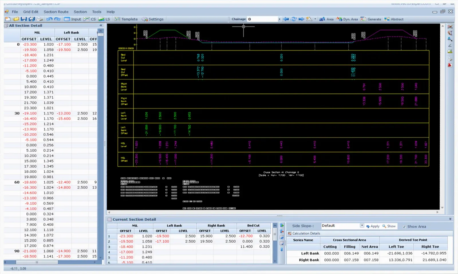
| Built-in CAD | Sections are real CAD drawings: zoom, pan, snap, click to read offset and level, and drag points with offset or level locked. No AutoCAD licence, no obligations. | Lock Offset · Lock Level · Get Reading · Snap · Copy, Move, Join, Erase |
| Drawing standard per project | Scales, datum band rows, fonts, line weights and precision are saved in the project, so every job keeps its own look. | CS 1:100 / LS 1:1000 × 1:100 default; 24 CAD fonts; 0–3 decimals |
| Move fast through long routes | Step, jump or animate through hundreds of sections from the keyboard. | ← → one · PgUp PgDn ten · Ctrl+G go to chainage · Animate |
| Quantities and output | ||
| Run All | Cut and fill areas and both toe points for every chainage and every layer in one go. | Stored with the project for the abstract and prints |
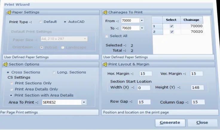
| Print wizard | Batch-print sections, sections with area details, or long sections onto page templates. | A0–A5, Letter; portrait or landscape; margins, row and column gaps |
| AutoCAD export | Send one section or the whole print layout to DWG for the drafting team. | Layers and colours kept |
| Project and workspace | ||
| Portable project file | Field books, designs, templates, section edits, settings and your own sheets travel in a single .CSF file. Email it, back it up, open it on another PC. | Older files are upgraded automatically, with a backup copy taken first |
| Reuse your standards | Copy section settings, layer settings and slope sets from any earlier project in one step. | Tools › Import Settings |
| A modern Windows app | Office-style ribbon, dockable panels, light and dark themes, a Start page with recent and pinned projects, sample projects and how-to videos. | Light · Silver · Blue · Dark Grey · Dark · Follow Windows |
Inside the software
Projects
Draw a template once for each typical section. Ships with a 7.7 km irrigation canal and a highway pavement sample to learn from.
Bed cut and both banks as separate layers, each with its own quantity.
Canal projects →Earth top, sub-base and bitumen layers from templates placed by gradient.
Road projects →Fill volumes with side slopes and toe points worked out at every chainage.
Bund and embankment projects →Formation and ballast templates along long L-sections.
Railway projects →Trench sections drawn as templates, with quantities per chainage.
Drain and sewer projects →Licensing
One licence per computer, with no per-project fees. No AutoCAD licence and no obligations: the CAD is built in. Ask for current rates for single seats, firms and training institutes.
In the box
No. Sections are drawn, edited and printed in the built-in CAD, so there is no AutoCAD licence to buy and no subscription to keep up. Export to DWG only when a client or drafting team asks for drawings.
Yes, from Excel. CivilSurvey recognises columns by their headings (Ch, Offset, BS, IS, FS, RL, Remark and common variations) and keeps a copy of your project before importing.
After you adjust sections, CivilSurvey takes the final levels, including toe points, and works out B.S., I.S. and F.S. readings from your bench mark. Change points are added wherever a reading would go outside the staff, and the arithmetic check runs at the end.
Send the .CSF file. Everything is inside it: field books, designs, templates, edited sections, settings and your own sheets. Files from older versions are upgraded when opened, after a backup is made.
A one-time payment per computer covers the licence and unlimited section generation. There is no subscription.
Talk to us directly